proWhen I first heard about Project Noah, I thought of that ipad app which is called the same name. That iphone and ipad application is made for nature lovers. It centers for nature – organisms and ecosystem.
Now that DOST (Department of Science and Technology) released the beta test for the much awaited Project Noah in the Philippines, I’m here to give a little glimpse about it and its features.
What is Project Noah?
Ok, it’s not really that Project Noah’s Ark or that famous ipad app for nature lovers. NOAH stands for Nationwide Operational Assessment of Hazards . With that acronym, it is obvious what it is about. It aims to provide assistance and assessment to disaster prevention and warning against possible floods, typhoons and other disasters.
Because the Philippines is prone to typhoons, tsunamis, earthquakes and volcanic eruptions, this project can help everyone especially warning agencies, LGUs and other sub-government units to provide information to everyone in their jurisdiction. NOAH project can also be used by anyone by going to their official website.
Project Noah Official Website
noah.dost.gov.ph
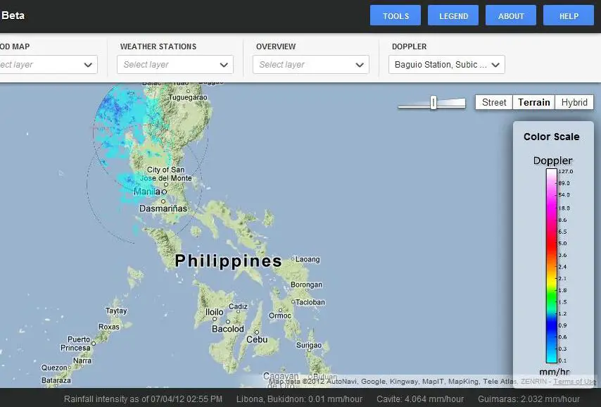
Features of Project Noah
- Weather outlook – you can assess rain probability so easily
- Flood map – anyone can see and monitor flooded areas and how serious they are
- Weather stations – you can find weather stations nationwide with blue markers
- Stream gauges – red markers show these gauges
- Rain gauges – green markers that show places with rain showers
- Doppler – shows movement of air and rain in real time
Project Noah Tools and Components
- Hydro met Sensors Development
- DREAM-LIDAR 3-D Mapping
- Flood NET-Flood Modeling
- Hazards Information Media
- Enhancing Geo-hazards Mapping through LIDAR
- Doppler System Development
- Landslide Sensors Development
- Storm Surge Inundation Mapping
The program also has some tools such as flood hazard which displays flood level depth and velocity. Rainfall intensity can be assessed regularly.
Project Noah by DOST uses advanced science and technology, state-of-the-art instruments and methods to construct high resolution hazard maps and information through different media and communication platforms such as those tools mentioned above and Google maps.
Scientists and famous organizations such as PAGASA, PHIVOLCS, and other agencies participate in making this project possible.
What do you think about this app and new project? Have you tried using it? Share us your thoughts and experience below.